


Gallery-quality prints · Independent artists · Décor to adore

, South Carolina (” by ArtHistory")

from $ 15
” by ArtHistory")

from $ 15
” by ArtHistory")

from $ 15
” by ArtHistory")

from $ 15
” by ArtHistory")

from $ 15


from $ 15
” by ArtHistory, 1934")
from $ 15
” by ArtHistory")

from $ 15
” by ArtHistory, 1984")

from $ 15
” by ArtHistory")

from $ 15
” by ArtHistory, 1963")

from $ 15
” by ArtHistory")

from $ 15
” by ArtHistory")

from $ 15
” by ArtHistory")

from $ 15
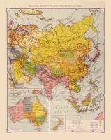
 Map (1884)” by ArtHistory")

from $ 15
” by ArtHistory")

from $ 15
” by ArtHistory")

from $ 15
” by ArtHistory")

from $ 15
 fro” by ArtHistory")

from $ 15
” by ArtHistory")

from $ 15
” by ArtHistory")

from $ 15
” by ArtHistory")

from $ 15
” by ArtHistory")

from $ 15
” by ArtHistory, 1956")

from $ 15
” by ArtHistory")

from $ 15
” by ArtHistory")

from $ 15
” by ArtHistory")

from $ 15
” by ArtHistory")

from $ 15


from $ 12
” by ArtHistory")

from $ 15